Waikato Regional Hazards Portal
To access the Portal, just click or tap on the 'Launch the Waikato Regional Hazards Portal' button.
Please note
- By using the Waikato Regional Hazards Portal you are deemed to have agreed to the Terms of Use.
- “Natural Hazard Information Hierarchy” classfications are included in the Portal's Layer Descriptions. You can read more about the hierarchy levels on this page.
- Also note that the Portal is not intended as a substitute for a Land Information Memoranda (LIM) which can be obtained from your local district/city council.
- For an overview of how Waikato Regional Council is complying with requirements under the LGOIMA Act and regulations to provide natural hazard information to territorial authorities, see our supporting information webpage.
What is the Waikato Regional Hazards Portal?
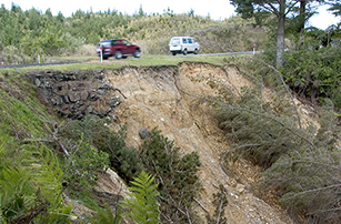
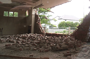
Natural hazards have the potential to cause disruption, damage properties and take lives.
They can also affect the value and insurability of properties. This is important to consider when purchasing a property, particularly with climate change projected to increase the frequency and severity of events such as river flooding and coastal erosion and inundation.
The Waikato Regional Hazards Portal has been developed to improve access to regional natural hazard information, and to help the public, local authorities and others manage risk and make informed decisions about their exposure to natural hazards.
The Portal contains all available (suitably robust) spatial hazard information that is held by Waikato Regional Council, as well as data from other organisations.
New and updated information will be added as required. It is intended to partially replace the online request for flood hazard information, although this service will still be available to answer specific questions and to provide flood levels where available.
Natural Hazard Information Hierarchy
The information contained in the Portal is of different levels of accuracy and has different scales of use, limitations and intended uses. This may be reflected in the visible display scale of the data. For some data, you will need to zoom in or out in order to make it visible – see the “Layer Descriptions” in the sidebar for a list of the data in each tab.
Also included in the Layer Descriptions section is an “Info Hierarchy Level” classification. This is the “Natural Hazard Information Hierarchy” which specifically supports user interpretation of quality, scale, and applicability for each of the WRC natural hazard data sets. For example, local scale flood depth data can be used to inform minimum floor levels for building consents, but the regional scale flood hazard data is only suitable as a ‘heads up’.
The following table describes each of the Hierarchy Levels:
Hierarchy level |
Description |
1 |
Property to local scale Information that is suitable to be used for property specific purposes, including within District Plans, or for:
The information is based on detailed modelling or hazards mapping that includes both current and future possible scenarios, along with the associated likelihoods and impacts. Users should make sure they are using the most appropriate natural hazards data available. Data held by other organisations may be better suited for property scale use or may be more up to date. Before using any of the Waikato Regional Council natural hazard data at property scale or for subdivision development purposes please contact the Waikato Regional Council Regional Resilience team for guidance. Further information on resource consenting is available on this website. |
2 |
Local to regional scale Information that is suitable to be used for District or Regional Plans, or as an initial indicator of where further investigation may be required. This information is NOT suitable for use at property scale, or for:
Waikato Regional Council recommends further investigation and using other applicable natural hazard data, if available, for property specific purposes. The information is generally based on modelling or hazard mapping but may not include both current and future possible scenarios. Users should make sure they are using the most appropriate natural hazards data available. Data held by other organisations may be better suited for property scale use or may be more up to date. Before using any of the Waikato Regional Council natural hazard data at property scale or for subdivision development purposes please contact the Waikato Regional Council Regional Resilience team for guidance. Note that further information on resource consenting is available on this website. |
3 |
Regional scale Information that is suitable to be used for the Regional Policy Statement, or regional scale studies/projects, or as an initial indicator of where further investigation may be required. This information is NOT suitable for use at property scale, or for:
Waikato Regional Council recommends further investigation and using other applicable natural hazard data, if available, for property specific purposes. The information is generally based on previous events or historic mapping/aerial imagery or LiDAR. Users should make sure they are using the most appropriate natural hazards data available. Data held by other organisations may be better suited for property scale use or may be more up to date. Before using any of the Waikato Regional Council natural hazard data at property scale or for subdivision development purposes please contact the Waikato Regional Council Regional Resilience team for guidance. Note that further information on resource consenting is available on this website. |
4 |
General information Information that is to be used for information purposes only, or as an initial indicator of where further investigation may be required. This information is NOT suitable for use at property scale, or for:
This information may be a draft, that is still subject to review, or indicative only. Waikato Regional Council recommends further investigation and using other applicable natural hazard data, if available, for property specific purposes. The information is generally based on national scale mapping, indicative regional scale mapping, or susceptibility from other existing data (e.g. LiDAR data). Users should make sure they are using the most appropriate natural hazards data available. Data held by other organisations may be better suited for property scale use or may be more up to date. Before using any of the Waikato Regional Council natural hazard data at property scale or for subdivision development purposes please please contact the Waikato Regional Council Regional Resilience team for guidance. Note that further information on resource consenting is available on this website. |
Information not currently available on the Waikato Regional Hazards Portal
Natural hazards information that is not spatial in nature, such as technical reports, may be available. Also, other spatial natural hazards information may be under development. See the Waikato Regional Council publications on this website or contact the Waikato Regional Council Regional Resilience team for guidance.