Waikato Regional Spatial Plan
A shared vision for the future
We’re working on a shared plan for the region’s future – thinking ahead about how we use land, build infrastructure and manage resources. Councils and iwi will come together to take a long-term, big-picture view, looking beyond district boundaries to understand the needs of our communities and the opportunities and challenges ahead.
What is a regional spatial plan?
A regional spatial plan (RSP) is a new long-term planning document required under the Government’s Planning Act. It provides a shared vision and strategic direction for how a region will grow and develop over the next 30 years or more.
The RSP will:
- Identify the main drivers of growth and change in the region.
- Show the broad location of future housing, infrastructure, transport networks, environmental areas and taonga we want to protect, and opportunities for things like renewable energy.
- Help coordinate planning and investment across councils and government agencies.
- Include objectives, maps and actions.
In the Waikato region, the RSP will cover the areas of Hamilton City, Waikato district, Waipā, Matamata-Piako, Hauraki, Thames-Coromandel, South Waikato, Taupō, Waitomo, Ōtorohanga, and part of Rotorua Lakes.
Who prepares the RSP?
The RSP is developed by a spatial planning committee (SPC), with support from a dedicated project team (the Secretariat) and specialist technical working groups that provide advice and expertise.
The SPC is a joint committee set up by the local authorities in the region. Each local authority can appoint one member to the SPC, although councils may choose not to do so. The SPC must also include a member with expertise in te ao Māori and Māori land development. In addition, the relevant Minister may appoint a member to the SPC.
What is the timeframe for preparing the RSP?
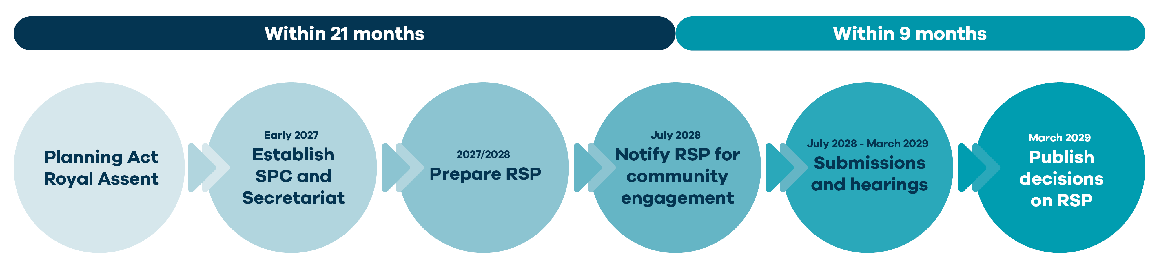
The Planning Act 2026 received Royal Assent on 30 September 2026. The first draft RSP must be released for community engagement within 21 months of that date. Final decisions on the RSP must then be published within 9 months of public notification.
Why do we need an RSP when councils already have long-term plans, district plans and growth strategies?
District growth strategies, local plans, and other planning work will help inform the RSP. These local plans provide important information about current and future growth, infrastructure needs, and community priorities.
The RSP brings this information together to create a single long-term vision for the Waikato region. Unlike council plans, which focus on individual districts or cities, the RSP looks across the whole region and helps coordinate land use, infrastructure, and resource management. This reduces duplication, makes better use of funding and resources, and supports more coordinated decision-making. Decisions made through the RSP will then be put into action through council long-term plans and land use plans.
How does Head Start fit in?
Head Start is a voluntary pathway that allows local councils to propose and lead changes to local government arrangements in their region. Regardless of the Head Start pathway they choose, an RSP must be ready for community engagement within 21 months of Royal assent. This falls before the timeframe for any Head Start arrangements.
What work has already been done?
Some groundwork for the RSP has already been completed, including an inventory and a draft framework.
The inventory is a collection of existing information, data, plans, and strategies from across the Waikato region. It helps identify work that has already been done and can be used to inform the RSP.

A draft framework has also been developed to guide how partners in the Waikato will work together to prepare the RSP. It outlines who will be involved, how we’ll work together, and the timeframes and resources needed.
Interested in learning more?
- Planning Bill: Planning Bill | New Zealand Legislation
- Planning New Zealand: Helping New Zealand plan, build, grow and protect the places that matter - Planning New Zealand
- Ministry for Cities, Environment, Region and Transport guidance: New Zealand’s New Planning System
If you are interested in learning more, please email: strategicandspatialplanning@waikatoregion.govt.nz
RSP partners
Waikato Regional Council | Thames-Coromandel District Council | Waipā District Council | Waikato District Council | Hauraki District Council | Matamata-Piako District Council | Hamilton City Council | | Ōtorohanga District Council | Waitomo District Council | Taupō District Council | South Waikato District Council | Rotorua District Council