Flood room status

Flood Room is monitoring. For information on current river levels, flows and rainfall accumulations, please visit our Environmental Data Hub.
Deactivated
Status: The weather is looking good and there are no risks of severe weather in the immediate forecast.
Action: Members of the Regional Flood Response team (including engineers, rivers and drainage operations, planning, communications and emergency management) continue their day jobs as part of their everyday mahi at Waikato Regional Council. A Regional Flood Coordinator and Regional Flood Liaison Officer are on duty 24 hours a day, maintaining an overview of river levels, weather patterns and forecasts affecting the Waikato.
Monitoring
Status: MetService has issued severe weather alerts or the weather forecast and/or catchment conditions could impact our schemes and/or the community.
Action: A Regional Flood Coordinator and Regional Flood Liaison Officer maintain an overview of river levels, weather patterns and forecasts affecting the Waikato. They will closely monitor the weather situation, environmental data and provide information to supporting agencies (such as civil defence, local councils and NZ Transport Agency Waka Kotahi) on potential impacts to assist with their planning and response.
Activated
Status: The weather is severe and there is a high risk of flooding and/or related natural hazards.
Action: Waikato Regional Council's flood response is scaled up with additional staff and resources deployed in the field, as well as in the office to manage flood schemes and provide information to civil defence and other agencies.
The Flood Room is monitoring
Updated at 4.15pm on Friday, 4 July 2025
Situation
While there are no active severe weather alerts, the Waikato region is under a Severe Thunderstorm Outlook.
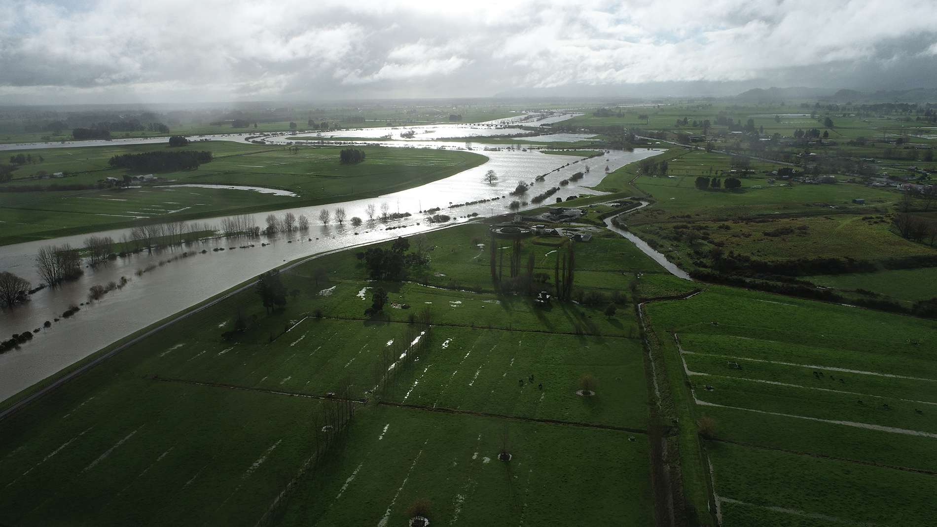
This week's rain has saturated our already sodden catchments, there is therefore a higher potential for localised downpours to cause impacts such as surface flooding and land slips, and rivers and streams to rise quickly.
The good news is that forecasts beyond Saturday and through to Wednesday, 9 July, show no severe weather.
Please keep up-to-date with MetService weather forecasts and messages from Civil Defence Emergency Management.
Visit our Environmental Data Hub for the latest river level and rainfall accumulations.
MetService forecast
There now severe weather watches or warnings for the Waikato region.
Severe Thunderstorms
There is currently a Thunderstorm Outlook for the Waikato region until midnight on Saturday (5 July).
Severe thunderstorm watches or warnings may be issued by MetService at short notice so please be alert for and act on these without hesitation – do not wait for further analysis by Waikato Regional Council.
For information on preparing for and keeping safe during a storm, see the National Emergency Management Agency's Get Ready website.
Likely/potential Impacts
Rivers and lakes
Rivers and lakes are continuing to recede from this week's rain. However, we may see increased river levels and flows over the next few days in some areas due to the potential of localised thunderstorms on top of rain that has already fallen.
The Waikato River will continue to be intentionally elevated to create storage capacity throughout the hydroelectric system.
Wind
There are no wind watches or warnings for the Waikato region. Please keep up to date with information from your local power provider, the NZ Transport Agency Waka Kotahi and local civil defence.
Coastal impacts
There are unlikely to be any significant coastal impacts.
Land instability
Areas that would normally experience land instability may be affected by any localised downpours that develop about the hill country and ranges of the region. People in these areas should remain vigilant for early warning signs of earth movement. Road users should plan ahead and keep up to date with the latest from their local council and the NZ Transport Agency Waka Kotahi.
What we're doing
Waikato Regional Council flood and drainage schemes
Our managed flood infrastructure has withstood the challenges of the recent weather. Our local operations staff remain on standby to monitor flood and drainage schemes.
Please note, drainage schemes will take time to return to the pre-event conditions. Rest assured our local operations staff are monitoring.
Waikato Regional Council telemetry
Our telemetry network continues to provide real-time data on rainfall and river levels and is monitored 24/7 by our Regional Flood Response team. Visit our Environmental Data Hub for the latest river level and rainfall accumulations.
Next update
The Flood Room will be updated by 11am on Monday (7 July) or sooner if the situation changes.


To ask for help or report a problem, contact us
Tell us how we can improve the information on this page. (optional)