“Dealing with complexity is where hydrological modelling comes into its own. Using detailed topography with idealised current and future rain conditions, we can predict what might happen in future weather events, even at scales we’ve never seen before.”
Waikato Regional Council Senior Engineer Steven Cornelius
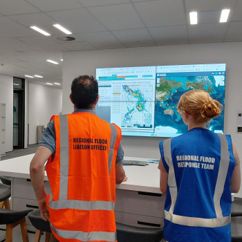
Regional flood response team monitors evolving situations
A drop of water lands on a high mountain range. Which way will it flow? And where will it end up?
There may be inherent unpredictability in complex systems, but recent advancements in hydrological modelling and adjacent fields have led to significant improvements in the predictive power at our fingertips – especially in catchment-scale assessments and flood prediction.
In 2024, the entire Waikato Region was mapped in high-resolution 3D, providing a crucial dataset to underpin new models.
“Hydrological modelling utilises computer simulations that represent how water moves through the landscape,” says Waikato Regional Council Senior Engineer Steven Cornelius, “taking real data about rainfall, land surfaces, soils and waterways and using physical laws to predict where the water will go and when.”
Waikato Regional Council recently developed a pioneering hydrological model of the Hauraki Plains catchment. The model now forms the basis of the risk assessment and a potential adaptation plan for the plain, providing expected flood water depths and extents for different scenarios in a scientifically advanced and robust way.
Steven, who is part of a wider team focused on regional resilience, says: “The work gives us a digital version of the entire Hauraki catchment – the basin-shaped area bounded by natural features, including hills and mountains, that ultimately drains water to the sea. This lets us experiment with rain, river flows and flooding without having to wait for the next storm.”
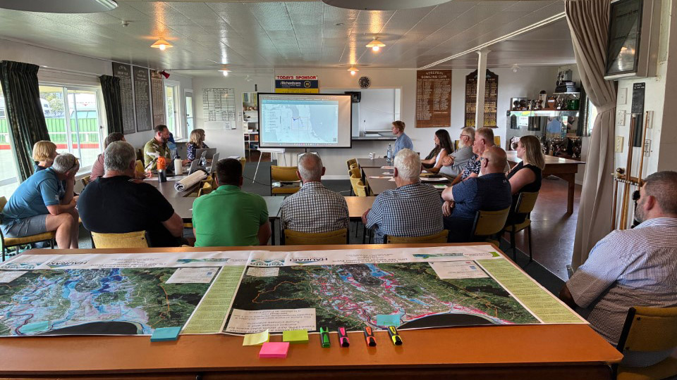
All models need to be rigorously calibrated and validated against past events to provide confidence in their level of accuracy, and the results aren’t released until they have been robustly sense-checked against community feedback. Community engagement is underway in the Hauraki Plains area to provide this check and help people understand that modelling is inherently complex and no model is 'perfect'. However, the model will provide insights into the way the catchment system works. The sessions also enabled residents to get to grips with what the modelled projections and scenarios show and how they might inform future initiatives.
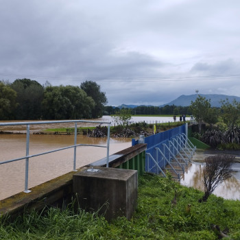
Criterion Bridge floodgate in Paeroa holds back flood waters
Real-world scenarios illustrate the potential and importance of increasingly advanced models. On 21 January 2026, when remote sensors along the Ohinemuri River upstream of Paeroa alerted the council to rising water levels, the flood gates were able to be closed well before the road and parts of the town could be affected by what ultimately swelled into a raging torrent.
“Sensors give us data to act on in real time.” says Steven. “In the case of Paeroa, we rely on water level gauges in the Ohinemuri River to trigger closure of the gates that protect the town. We are now able to run forecast and recorded rainfall through a hydrological model to predict river levels in advance. This gives additional preparation time for our field crews to close the gates and additional lead time for emergency response planning.”
“Dealing with complexity is where hydrological modelling comes into its own. Using detailed topography with idealised current and future rain conditions, we can predict what might happen in future weather events, even at scales we’ve never seen before.”
“This enhances our ability to proactively plan and reactively support communities. It means we can better prioritise cost-effective asset maintenance and construction in the best places, to optimum specifications. And it means, when another sensor starts blinking at us, we can make better real-time decisions – that reflect where the downstream impacts could occur – to keep communities safe.”
Looking to the future, hydrological modelling will also enable the exploration of different climate change projections and the development of more effective nature-based solutions (where feasible) to help absorb, redirect, work around and identify opportunities in natural flow patterns, rather than attempting to hold back change.
“Water always finds a way.” says Steven. “The beauty of hydrological modelling is that, instead of trying to fend off the forces of nature, it seeks to understand them and anticipate them – informing solutions that work with them to achieve better outcomes for communities”.
Waikato Regional Council is in the process of developing catchment-scale hydrological models for catchments across the region and expects to be in a position to start sharing these with communities beyond the Hauraki Plains during 2026.
The frequency and intensity of weather events highlight the growing importance of hydrological modelling.