The Waikato Integrated Scenario Explorer (WISE) is a spatially‑explicit modelling tool that integrates economic, demographic, environmental, and land‑use data to assess the impacts and trade‑offs of future development and policy scenarios. Built on a modular platform adaptable to other regions—including Auckland and Wellington—WISE supports evidence‑based planning, and a short introductory video is available to learn more.
How WISE works
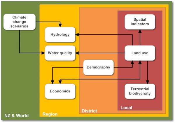
The overall system design for WISE Version 1.4 (Figure below) consists of an integrated set of models that operate across four spatial scales: New Zealand & the World, the Waikato region, cities and districts and local for the land use change (100 m × 100 m grid cells) and terrestrial biodiversity models (100 m × 100 m grid cells). WISE consists of more detailed sub-models, each of which varies in detail, data, and internal structure. WISE operates on an annual time step, with simulations beginning in 2018 and ending in 2067. Arrows represent links or flows among the different models. The direction of the arrow shows the direction of flow.
The development of WISE
The development of WISE consisted of a four stage process:
Design and system definition
Collection of data and model components
integration and calibration, and
validation and optimization.